ShopDreamUp AI ArtDreamUp

Deviation Actions


Description
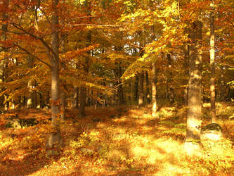
A stranger in a foreign land..
This is Anzac Cove, a small cove on the Gallipoli peninsula in Turkey. It became famous as the site of World War I landing of the ANZAC (Australian and New Zealand Army Corps) on April 25, 1915. The cove is a mere 600m long, bounded by the headlands of Ari Burnu to the north and Little Ari Burnu, known as Hell Spit, to the south. Following the landing at Anzac Cove, the beach became the main base for the Australian and New Zealand troops for the eight months of the Battle of Gallipoli.
The first objective for soldiers coming ashore in enemy-held territory was to establish a beachhead, that is, a safe section of beach protected from enemy attack where supplies and extra troops could be safely brought ashore.
Anzac Cove was always within kilometre of the front-line, well within the range of Turkish artillery though spurs from the high ground of Plugge's Plateau, which rose above Ari Burnu, provided some protection. General William Birdwood, commander of Anzac, made his headquarters in a gully overlooking the cove, as did the commanders of the New Zealand and Australian Division and the Australian 1st Division. It was on 29 April that General Birdwood recommended that the original landing site between the two headlands be known as "Anzac Cove" and that the surrounding, hitherto nameless, area occupied by his corps be known as "Anzac".
The beach itself became an enormous supply dump and two field hospitals were established, one at either end. Four floating jetties were quickly constructed for the landing of stores, later replaced in July by a permanent structure known as "Watson's Pier". The volume of stores quickly overflowed onto the adjacent beaches; firstly onto "Brighton Beach" to the south of the cove and later onto North Beach beyond Ari Burnu. Three wireless radio stations were established on the beach to maintain contact with the fleet.
While the cove was relatively sheltered from shellfire from across the peninsula — the Chanak forts, as well as the Turkish battleships Turgut Reis and Barbaros Hayreddin anchored in the Dardanelles, shelled the waters off the cove — it was partially exposed to view from Gaba Tepe to the south and completely open to view from Nibrunesi Point at the southern tip of Suvla Bay to the north. Nibrunesi Point was under the guns of the Royal Navy so was never used to fire on Anzac, however the well-concealed Turkish battery at Gaba Tepe, known as "Beachy Bill", was a constant menace.
Despite the shelling, Anzac Cove was a popular swimming beach for the soldiers — at ANZAC it was a struggle to supply sufficient water for drinking, there was rarely any available for washing. When swimming, most soldiers disregarded all but the fiercest shelling rather than interrupt the one luxury available to them. Concealed Turkish snipers also targeted swimming soldiers.
Gallipoli, Turkey, Europe
Image size
3584x2016px 4.63 MB
Make
Panasonic
Model
DMC-FZ50
Shutter Speed
10/4000 second
Aperture
F/5.6
Focal Length
7 mm
ISO Speed
100
Date Taken
Jun 16, 2010, 4:36:12 AM
Comments3
Join the community to add your comment. Already a deviant? Log In
Incredible view of history